Important note. These maps are a first attempt to portray the geographical distribution of Georgian fungi. They are not exhaustive. Caution should therefore be exercised in interpreting them, as inconsistencies, mistakes and omissions may be present. The boundaries used in these maps have been selected because many are similar to the geobotanical boundaries influencing the distribution of plants associated with these fungi. They may not represent current boundaries, and do not represent any political opinion.
Function. Each map shows the distribution of a single fungal taxon recorded from Georgia.
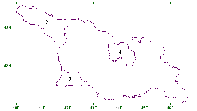
Map conventions. For each organism, a map of the whole of Georgia is used. Two guide maps are shown below. The first is a guide to Georgia and its autonomous republics (primary administrative boundaries). The second is a guide to the raions and town councils (secondary administrative boundaries) of Georgia and its autonomous republics. On the distribution maps themselves, lightly shaded areas contain at least one record accurate to autonomous republic level, while moderately shaded areas contain at least one record accurate to raion or town council level. Individual green squares represent separate records accurate to at least 10 minutes of latitude and longitude. A shaded area behind a green square may relate to the same record. For all maps, the green squares cover roughly an equivalent area.
Georgia and its autonomous republics (see map above). 1 Georgia [excluding autonomous republics] 2 Abkhasia Autonomous Republic. 3 Adzharia Autonomous Republic. 4 South Osetia Autonomous Republic.
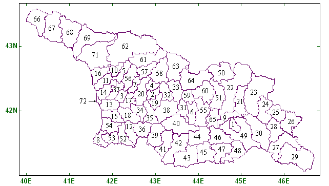
Raions and town councils of Georgia and its autonomous republics (see map above). Abasha (3), Adigeni (36), Akhalkalaki (42), Akhaltsikhe (39), Akhmeta (23), Ambrolauri (58), Aspindza (41), Bagdadi (35), Bolnisi (47), Borjomi (40), Chiatura [town council] (32), Chkhorotsku (5), Chokhatauri (18), Dedoplistskaro (29), Djava [South Osetia] (64), Dmanisi (45), Dusheti (22), Gagra [Abkhazia, town council] (66), Gali [Abkhazia] (16), Gardabani (49), Gori (55), Gudauta [Abkhazia] (67), Gulripshi [Abkhazia] (69), Gurdjaani (28), Kareli (6), Kaspi (65), Kazbegi (50), Keda [Adzharia] (53), Kharagauli (38), Khashuri (31), Khelvachauri [Adzharia] (8), Khobi (14), Khoni (7), Khulo [Adzharia] (12), Kobuleti [Adzharia] (54), Kvareli (25), Lagodekhi (26), Lanchkhuti (13), Leningori [South Osetia] (51), Lentekhi (61), Marneuli (48), Martvili (56), Mestia (62), Mtskheta (9), Ninotsminda (43), Ochamchire [Abkhazia] (71), Oni (63), Ozurgeti (15), Poti [town council] (72), Sachkhere (33), Sagaredjo (30), Samtredia (17), Senaki (37), Shuakhevi [Adzharia] (52), Signakhi (27), Sukhumi [Abkhazia] (68), Tbilisi [town council] (1), Telavi (24), Terjola (2), Tetritskaro (46), Tianeti (21), Tkibuli [town council] (4), Tsageri (57), Tsalendjikha (10), Tsalka (44), Tskhaltubskiy (20), Tskhinvali [South Osetia] (60), Vani (34), Zestafoni (19), Zugdidi (11), Znauri [South Osetia] (59)
Additional information. Please note the following points.
Because the Georgian heartland (ie Georgia excluding autonomous republics) is never shaded lightly in the present work, maps with neither shading nor green squares may be encountered. These should be interpreted as representing records known to occur in the Georgian heartland, but without further information sufficient to allocate a raion, town council or green square. It should also be remembered that records only identifiable as from the Georgian heartland may occur for species on maps with other shading or green squares, and again the Georgian heartland information will not be shown. | |
Green squares marking a fungus record with an exact locality sometimes occur within raions or town council areas which are not shaded, or which are lightly shaded. If such a green square is very close to a darkly shaded area, particularly if that area does not bear a green square, it is likely that there is an inconsistency between the boundary data and the co-ordinates for that record. If the green square, however, is in an area near no dark shading, it indicates a record which has only recently been allocated an exact co-ordinate, and which has not yet been up-dated to include information identifying the raion or town council where it was collected. In all such cases, the user is strongly advised not to extrapolate the name of the raion or town council as a place of collection from the locality of a green dot. | |
Some fungi have been recorded from Georgia with identifications not only at species level, but also at subspecific level. In those cases, species level identifications are displayed on separate maps from those made at subspecific level. This means that the species level map does not include the records on the subspecific maps. Where subspecific taxa are recorded from Georgia, the user is advised to consult all maps relating to that species and its subspecific taxa, to have a full understanding of the known distribution of the species. | |
In the case of records with latitude and longitude data accurate to the nearest ten minutes, the location is shown by a green square, and the centre of that square marks the mid point of the ten minute square in which the record was made. This may at times make the location of recording of, for example, a terrestrial fungus appear to be in the sea. In the current version of these maps, these two categories of square are visually indistinguishable. |
| Previous page
Biodiversity Website: home page |