INTERPRETING MAPS
Function. Each map shows the distribution of a single fungal taxon recorded from Ukraine. Where the taxon is known to occur in Ukraine, but with no more detailed information, no map is shown.
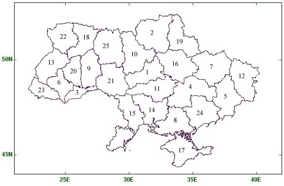
Map conventions. For each organism, when first viewed, a map of the whole of Ukraine is displayed, with a hyperlink above the map to the right permitting a return to the Fungus Names menu. The user is likely to find this hyperlink a more efficient in returning to the Fungus Names menu than by using the browser 'back' button. A guide to the oblasts (primary political boundaries) of Ukraine is provided below. Shaded areas contain at least one record accurate to oblast' level. Individual green squares represent separate records accurate to at least 1 minute of latitude and longitude. The presence of a green square within an oblast' will automatically result in that oblast' being shaded, so that it is possible for an oblast' to be simultaneously shaded and with a green square on the basis of a single record. For all maps, the green squares cover roughly an equivalent area.
Zooming the maps. When a map of the whole of Ukraine is displayed, it is possible to zoom in to any individual oblast'. Zooming the map helps to separate clustered green squares. Hold the mouse pointer over the desired oblast', making sure it is not exactly over any green square which may be present, then click (the zooming function does not work if the mouse pointer is held directly over a green square). An enlarged detail of the original map will be shown, with the desired oblast' in the middle, the name of that oblast' above the map to the left, and a 'zoom out' hyperlink above the map to the right. When viewing a zoomed-in map, it is possible to move to adjacent oblasts without returning to the main map: hold the mouse pointer over the desired adjacent oblast', making sure it is not exactly over a green square, then click. The user is likely to find this hyperlink a more efficient in returning to the main map than by using the browser 'back' button.
Accessing source information. It is possible to view summarized information from the records used to produce each map. When the computer's mouse pointer is directly over a green square on any map, or over the shaded part of the desired oblast of a zoomed-in map, the mouse can be clicked to indicate interest in that location. Every relevant record will be displayed in a new window above the map. If the mouse pointer is over the shaded area of the desired oblast of a zoomed-in map, the title bar of the new window will provide the name of the oblast' in question, and all records from within that shaded area will be displayed (including records giving rise to any individual green squares also present within that shaded area). If the mouse pointer is over an individual green square, the title bar of the new window will provide the latitude and longitude co-ordinates of the point clicked, and all records accurate to at least 1 minute of latitude and longitude which are near the point clicked will be displayed. For the purposes of these maps, "near" is not precise, but normally means closer than 6 km. Where an individual record was derived from a published source, a hyperlink may be displayed providing access to bibliographic information about the published source. If that hyperlink is clicked, that bibliographic information is displayed in the same window. To return to the map, close the window.
Additional information. Please note the following points.
Some fungi have been recorded from Ukraine with identifications not only at species level, but also at subspecific level. In those cases, species level identifications are displayed on separate maps from those made at subspecific level. This means that the species level map does not include the records on the subspecific maps. Where subspecific taxa are recorded from Ukraine, the user is advised to consult all maps relating to that species and its subspecific taxa, to have a full understanding of the known distribution of the species. | |
In the case of records with latitude and longitude data accurate to the nearest ten minutes, the location is shown by a green square. Where the information giving rise to that square is accurate to the nearest minutes of latitude and longitude, the square is centred over those minutes. Where the information giving rise to that square is accurate only to the nearest ten minutes, the centre of that square marks the mid point of that ten minute square. This may at times make the location of recording of, for example, a terrestrial fungus appear to be in the sea. In the current version of these maps, these two categories of square are visually indistinguishable. |
INTERPRETING DATA
Type of information. It is important to note that the source record text displayed represents current opinion in the Latin alphabet, and not original information. In the database used to produce these maps, original information is stored separately from current opinion about what that original information means. The original information behind these maps is frequently in the Cyrillic alphabet (for example "И.А. Дудка" rather than "I.A. Dudka") and names may have changed (for example, an original location might have been "Stalino" where the current name of the place is "Donetsk", or the original identification of a fungus may have been Hysterium pinastri where the currently accepted name is Lophodermium pinastri).
Quality of data. Not all information in the source record text has been verified to the same standard. As a result, it is not difficult to find inconsistencies between records in the spelling of names of some places and people. In general, the names of oblasts, raions, and associated organisms, together with the words describing substrata, have been checked and should be consistent. The same should be true of dates of collection. The names of individual locations within raions, and of collectors and identifiers are likely to be more variable. Where editing has occurred, information about individual locations within raions is presented with the name of the largest place first, with further names of any smaller places following in order of size, each name being separated by a semi-colon and a space. Any further information accompanying a place name ('near', '2 km to north' etc.) is presented after the place name it qualifies, separated from that place name by a comma and a space. A typical entry for a location might therefore read: 'Republic of Crimea; Yalta gorsoviet; Ai Petri mountain, 1 km to east; Funicular station, near'.
Sources of records. The records used to generate these maps have come from a variety of sources. These include living and dried reference collections, published and unpublished written records, and field observations backed by neither a specimen nor a written account. If the current record was derived from a living or dried reference collection, or from a published record, the text displayed on screen provides information about that source. If the current record was derived from an unpublished written record, or from a field observation backed by neither a specimen nor a written account, no screen information about source is provided.
Duplication of data. In the database, there are many instances where information about the same single observation is stored in several different records. This may arise, for example, when information is extracted from several different scientific papers which all refer to the same specimen. The presence of several records for a point clicked is therefore not necessarily evidence that the fungus was recorded more than once.
Name of identifier. The original identifier of the fungus in each record is stored in the database where that information was available at the time of keyboarding. If the name originally allocated to the fungus is still in use, that person is credited as the identifier. Where the name in current use is different from the name originally allocated, the name of the person responsible for the change (often the curator of the database) is given as the identifier. If the current name is a nomenclatural (obligate) synonym of the original name, redisposition of the name is a largely mechanical process, and may not imply a particular expertise on the part of the curator.
| Previous page |